© Ski Transfers

Snow report, 3 April 2025
We’ve seen a real mix of weather over the past week here in Alpe d'Huez. Last Saturday brought a fresh top-up of snow, setting us up for a great powder day with sunshine on Sunday. Since then, we’ve had a bit of everything; sunshine, strong winds at higher altitudes, rain, and more snowfall.
Lately, the weather has been quite unpredictable, with some days originally forecast to be sunny ending up snowy instead! This uncertainty has largely been due to the influence of the Foehn wind.
The next few days
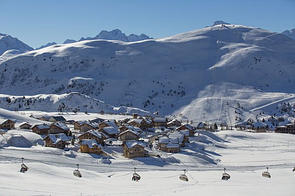
At the moment, it looks like we have a spell of dry, sunny weather ahead. With the snow melting more quickly due to slightly higher-than-average temperatures, the best skiing is now above 2,000m. You may still find some powder on high, sheltered north-facing slopes.
Although it has felt cold at times, and the freezing level briefly dropped to around 1,400m on Tuesday helping to preserve lower slopes, temperatures are now on the rise. The freezing level is expected to climb between 2,000m and 2,900m over the next few days, with temperatures struggling to dip below freezing. This is due to a northern high-pressure system bringing in milder weather. So, make the most of the spring skiing.
Avalanche risk
After recent strong winds, rain, and snowfall, there has been some avalanche instability across the Northern Alps, mainly due to glide cracks and cold, dry slab avalanches, often triggered by skiers. The current avalanche risk is 3 out of 5 above 2,200m, with an additional danger of wet snow avalanches. Be sure to check the avalanche warnings in Alpe d'Huez before even thinking about heading off-piste.
Watch this
Top tips if you are skiing this week
We have spring ski conditions now and although the pistes are quiet, they will begin to get busier as the European school holidays for Easter begin next week. There are plenty of events planned in April in Alpe d'Huez, check out our events calendar.
- The temperature is changeable in the mountains, we’re properly spring skiing now, but it may be a little chilly out of the sun. So thinner layers, a shell jacket rather than a thick winter coat, more lightweight gloves are a good idea, and open those vents as the day warms up!
- Don't forget the sunscreen! Even when the windchill is high, the sun in the mountains is still intense.
- You’ll need your goggle lenses for sun this week
- Early morning the pistes are harder packed and maybe a bit icy and then a bit slushy in the afternoon. So coordinate your ski time to whichever conditions you prefer.
- Get your skis and boards waxed as the wetter snow can slow you down a bit!
- Book the sunny restaurant terrace for a long lazy lunch
Still time to enjoy some late season skiing, check out - Why come spring skiing in Alpe d'Huez.
Updates and be social
Scroll down to see live forecasts, lift status, links to webcams and above for real time photos from Alpe d'Huez. We will be updating this snow report page every Thursday, so check back in with us next week to see how the pistes are doing and what you can expect from the snow forecast for the next seven days.
We need you!
If you're in Alpe d'Huez this week, we'd love to see your images, especially videos, of what you've been up to. So when you post to Facebook or Instagram, please tag us SeeAlpe d'Huez. Every week, we'll be posting our favourite videos and images here and sharing on our social media, along with our weekly resort snow report.
Have a great week out on the pistes!